


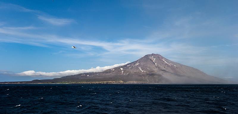
Secrets of a Northern Kuril Island
When the Sea of Okhotsk became “domestic” in 2014 and 52,000 square kilometers of formerly international waters came under Russian jurisdiction, the country had to take a fresh look at the defense of its eastern borders. It needed to build a full-fledged military base on one of the Kuril islands to ensure the safety of waters of the Sea of Okhotsk and a large part of the eastern coast of Russia. Matua was the obvious choice. In May and June, the Defense Ministry and the Russian Geographical Society made an exploratory expedition to the island.
 -
- Secrets of Matua Island
During World War II, Matua Island was one of Japan’s staunchest fortifications. The small island was a base for major military units. It was equipped with all necessary infrastructure and a multi-layered defense system was deployed there. Fortunately, the success of the Kuril landing forced the Japanese to surrender the island without a fight. Compared with the less fortified islands of Paramushir and Shumshu, Matua was a real fortress and Soviet troops risked serious losses assaulting it.
It remains unclear what the Japanese were guarding so fiercely, but even the small part of the fortifications that was examined astounds the imagination. Huge fortifications, underground bunkers with walls 3 feet thick, large-caliber guns and plenty of equipment. A military airfield with three runways that were probably heated by hot springs...
According to various accounts, the Japanese may have built a secret transshipment base for their submarine fleet, a top-secret research lab and even a repository for the Empire’s treasures. Exactly what was there remains to be discovered because all that the Soviet troops found there in 1945 was a bunch of military construction workers whose job was to mothball the facility. Yevgeny Vereshaga, head of the Kamchatka-Kuril regular expedition, said the Japanese garrison had obviously prepared the island for surrender to Soviet troops. All the really valuable stuff was probably burned, blown up or sent to the bottom of the ocean. But it’s possible that something was left inside the island. Underground utilities were found carved into basalt and finished with wood.
The Russian Geographical Society and the Defense Ministry expedition recently began exploring the island, yet still the researchers have more questions than the answers. Only a small coastal section of the island has been explored, so the main discoveries lie ahead.
Fieldwork
The deputy commander of the Pacific Fleet, Vice Admiral Andrei Ryabukhin, said the expedition’s task is to explore the island’s infrastructure and see whether it can still be used today. Next, researchers will scout out the engineering, radiochemistry and bacteriology of the area.
It took the expedition only a month (the expedition left Vladivostok on May 7 and arrived on the island on May 14) to conduct a vast amount of work. Exploration of the coastal and lowland parts of Matua Island is complete. Overall 97 sites were examined. These include bunkers in coastal and lowland areas, observation points, range-finder stations, and artillery and machine-gun pillboxes. Specifically, 50 of 86 artillery and machine-gun pillboxes have been examined so far.
Exploration of the coast of Ainu Bay on Matua Island is also finished. During World War II, it housed a set of 127-mm all-purpose guns on six positions and nine machine-gun and artillery pillboxes that were part of the Japanese garrison’s battalion defense station. Detailed examination provided information for blueprints of underground and above-ground fortifications as well as the overall defensive space. Expedition members think this data might reveal the plan of defense conceived by the Japanese garrison commanders. Military historians on the expedition analyzed the condition of pumping, diesel, and drilling stations as well as tanks for storing water and fuel. Each site was described and mapped. Some sites may have potential for future use, assuming they are brought up to date and outfitted with today’s technology. A concrete runway at the airfield will be the first of these sites to get up and running in the near future.
In addition, the island was partially scouted, namely the present landscape of the southeastern part. Researchers studied the origins of the low-lying surfaces and heights up to 200 meters. They also cleared dirt from a number of coastal cliffs up to 30 meters high and bookmarked key sections (drill pits) to a depth of 4 meters to determine the age of the island. The total length of the exploration route was about 300 kilometers. The explorers saw ancient lava and weathered crust that scientists estimated to be tens of thousands of years old. The research and survey groups also determined that Matua Island had suffered at least 30 tsunamis throughout its existence.
The work of the expedition is going on. Scientists are examining the fortifications in detail and cleaning up the underground utilities. Very soon, the coastal area of the island will be prepped to handle a large amphibious assault ship so additional equipment can be delivered there. However, the expedition doesn’t expect its work to be finished anytime soon. According to Defense Ministry representatives, that will take more than a year.
The Key to the Sea of Okhotsk
The official expedition has not yet provided answers to the mysteries and secrets of Matua. Nothing sensational has been found – no underground bunkers, no labs, no weapons. No matter how things turn out, though, as the main prize is the island itself and its special geography. Matua is almost the midpoint of the Kuril islands and is right next to the Krusenstern Strait. This spot might be called the lock on the gate into the Sea of Okhotsk. Controlling the straits between the islands makes it possible not only to ensure the safety of the interior waterways but also to guarantee free passage of one’s own fleet to the Pacific Ocean. At the same time, the island can be considered a focal point of air force strategy.
Some experts think that “only the naval component of the expedition makes sense,” said Vladimir Gorlov, associate professor of the Russian economic and social geography division of Moscow State University’s geography department. “And first of all, you need to get the island’s infrastructure in order and completely restore it to meet the needs of the modern Russian armed forces. The island holds promise when conceived of as a stopping point. But not so much for the navy as for the air force. The most pressing problem in the Kuril islands now is air connection. All aircraft coming to the islands from the mainland have to turn around almost immediately and fly back because they’re running low on fuel. A new airport on Matua seems very promising due to Russia’s need to strengthen its military position in the Far East.
According to one expert, the expedition is necessary to offer a public “cover story” for construction of modern military infrastructure. “For the naval component of island development to take shape, it needs to be scientific to some extent, like maybe studies of nearby currents and the geology of the island. They could take it a step further and try to uncover the secrets of Matua, said Gorlov.
Experts surveyed by EastRussia believe that the island infrastructure will be used for military purposes in the very near future. “The results that the naval component of the expedition achieves by year’s end will likely need clarification on some details, but they’ll be enough for a final decision on establishing a Matua base as a defense at Russia’s borders,” said Victor Pavlyatenko, the lead researcher at the Center for Japanese Studies.
“Remember how fast the naval base in the Arctic, on Kotelny Island, was rolled out two years ago. “An approach for ships; roll-out of an airfield; aircraft intake; another approach for ships; a garrison wintering there. And the process is underway.” That’s the example scenario another EastRussia interviewee offered. “The decision on Matua has probably been made already. So in the near future, the country will see a lot of exciting stories about the military infrastructure on the Far East island.”
 Штрафовать за управление электросамокатами в состоянии опьянения будут в России
Число подтопленных участков увеличилось в Бурятии
Два поселка подтопило в Хабаровском крае
Межмуниципальный режим ЧС ввели в Бурятии
Генпрокуратура: в регионах ДФО срываются сроки строительства дамб
Шахтерам светит тяжелый год
«Ты там не нужен!» Что увидели путешественники в сердце Охотского моря
Приусадебные участки подтопило в Бурятии
Речному флоту не хватает дна
Пульс угля — 15 апреля: угольная промышленность в моменте
Бюллетень EastRussia: отраслевой обзор рыбной промышленности ДФО – весна 2024
Штрафовать за управление электросамокатами в состоянии опьянения будут в России
Число подтопленных участков увеличилось в Бурятии
Два поселка подтопило в Хабаровском крае
Межмуниципальный режим ЧС ввели в Бурятии
Генпрокуратура: в регионах ДФО срываются сроки строительства дамб
Шахтерам светит тяжелый год
«Ты там не нужен!» Что увидели путешественники в сердце Охотского моря
Приусадебные участки подтопило в Бурятии
Речному флоту не хватает дна
Пульс угля — 15 апреля: угольная промышленность в моменте
Бюллетень EastRussia: отраслевой обзор рыбной промышленности ДФО – весна 2024